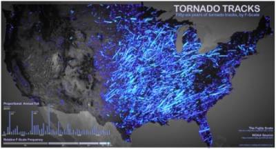
 This brightly glowing map shows the tornadoes that have touched down in the United States since 1956. Notice how strong they are in Texas, Oklahoma, and Missouri.
Made by John Nelson with data from NOAA, this map shows every tornado as a line, which marks the path of the storm. The brightness of the lines corresponds to each twister’s Fujita scale, which is one way of measuring how intense it is. It’s remarkable to look at this map and see how much of the U.S. has been hit. Given how tornadoes are becoming more frequent and more deadly isn’t it time you protected your family with a safe room from Tornado Alley Armor? Check us out at www.tornadoalleyarmor.com and give us a call if you have any questions. 918-518-1551.


